Assessment search is a publicly available online service for private, personal, non-commercial use. It provides easy access to property information about most taxable properties across British Columbia with the exception of some Indigenous properties, and properties with certain use codes; including recreational properties, such as parks and playing fields, and major industrial properties, such as pulp mills, and utilities.
Anyone can use the service for private, personal, non-commercial purposes. Businesses wishing to learn more about commercial access to assessment information should contact BC Assessment at 1-866-valueBC (1-866-825-8322 Ext. 00118).
The terms of use is a legal agreement between BC Assessment and any user of the assessment search service. It is assumed by BC Assessment that use of the service provides agreement with the terms of use. Anyone who wishes to review and/or print the terms of use can do so from the main page of the assessment search service by clicking the link available under the search bar. These terms specify, among other things, the legal use of the service which the user must adhere to.
Special agreements with each Indigenous community must be negotiated by BC Assessment prior to including that specific community’s property information. Agreements do not exist for every Indigenous community, and some Indigenous communities with an agreement have not yet submitted their property information to BC Assessment.
No, property owners do not have the authority to request that their BC Assessment information be removed from the assessment search service.
Please contact a BC Assessment representative at 1-866-valueBC (1-866-825-8322) to discuss obtaining additional property details.
The search bar on the assessment search page offers an auto-complete feature that tries to predict your request as you key in the order that the information is typed. For example, typing “123 Queen” will result in the first 10 options (if available) beginning with that exact same sequence of characters.
If you do not see your desired option in the 10 predicted options, continue to key your request and note that the presented options will update.
All of the required search information is found on the assessment notice. (i.e. address, roll number, PID or plan). If you do not have your assessment notice,
please contact the Regional Office in your local area to request a copy.
For address: Follow the suggested format provided in the search bar for optimal results. Type in the address given at the bottom of the assessment notice. Make sure to include special characters (i.e. “-“) and spaces. If the address has a unit # but there is no “-“between it and the street number, type it in the search bar without a “-“. In the example below you would type: 1234 Anywhere Street.

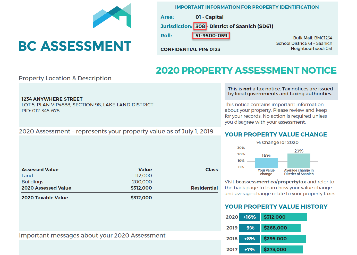
For roll number: The roll number is usually unique for each property, but there are some instances where this is not true. To ensure that you get the correct property for the roll number you have, enter the jurisdiction number located above the roll number at the top right of the assessment notice first, and then the roll number. Do not include the “- City/Town name” shown on the notice.
The jurisdiction number and roll number should be typed in the search bar in the following format. In the example below you would type: 308 as jurisdiction number and 519500059 as roll number.

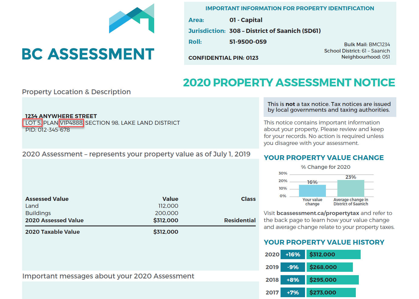
For plan: The plan number is not a unique identifier for a property. As a result you must type in a few other property identifiers that in combination will retrieve the property you are looking for. The full set of property identifiers are the plan number, lot number, jurisdiction number (without the city or town part), and the roll number. These identifiers can be found on the property assessment notice in two places: the box at the top right (jurisdiction and roll) and the box near the top left on the notice (lot number, plan number). Please review the picture below. The numbers must be typed in the search bar in the following format, including special characters and spaces. The auto-complete will make suggestions below the search bar and you can select the correct one as soon as it is displayed in the list.
In the example below you would type: VIP4888 as Plan and 5 as lot.

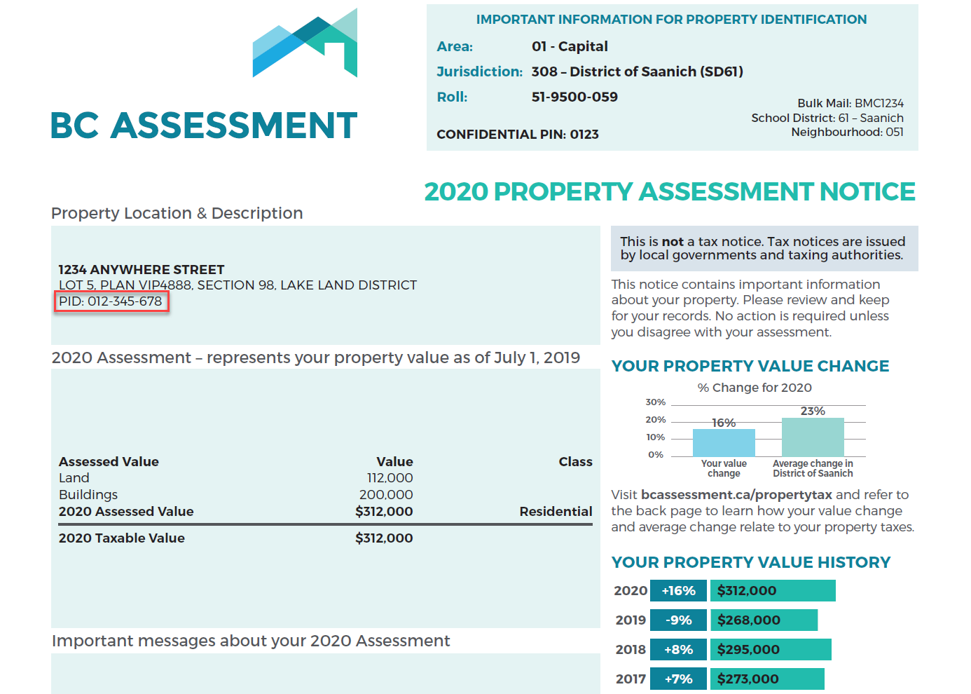
For PID: A parcel Identifier, or PID, is located on the property assessment notice in the Property Location & Description box. See the image below for the location of your PID on your assessment notice. When searching by PID, dashes(-) are not required.
In the example below you would type: 012345678.

If no auto-complete options are displaying below the search bar this indicates that:
● The information being keyed-in for which Assessment search has no records;
● A cut-and-paste method has been used to enter information, or
● The information is not recognized as an address by the search routine (use the watermark in the search bar as a guide to how to format the address). You may have to refresh the browser to see the watermark.
Search for a condo/strata building the same as you search any address. When the address search determines that a strata building is being searched on, it displays a subset of the units and indicates on the first line or two, the option to list all of the strata units. If the unit you are looking for is not on the initial list, simply click on the line with the wording “select to see all units…" and this will take you to a new page with the full list of strata units within the building. From this list, select on the individual unit of interest.
The images posted to Assessment Search are taken from a vantage point, such as the street or a sidewalk, that is accessible to members of the public. It is important to note that BC Assessment blurs portions of images, including vehicle license plates and faces of people.
Property owners do not have the authority to request that their property not display an image. There are three kinds of property images displayed in Assessment Search: BC Assessment street front images, Google Maps API street front images, and BC Assessment images that are not street front images but are posted at property owner request. This third option is available only if strict conditions are met.
Nearly 80% of properties include images. BC Assessment images obtained through the street front program will remain on the service as per our policy, unless a specific problem with the image is identified (for example a licence plate is readable). Each image obtained through the street front program has been confirmed to comply with the province of BC’s privacy legislation. To report a problem with a property image in assessment search, please click “Report a Problem” at the bottom of the property image or visit our
Property Images page for more information.
Google provides a process that enables property owners to request that parts of or all of the
Google Street View image of their property (identified by the Google watermark on the image) will be blurred.
Additional information about the three kinds of images posted to Assessment Search is found on BC Assessment’s
Property Images page.
Updating property images is a significant undertaking for such a geographically large province as British Columbia. While we strive to have property photos as current as possible, not every property can be updated frequently due to geographical and accessibility constraints.
In some cases, there is no image because neither Google nor BC Assessment has taken a street front image of the property or the image may not be available.
Assessments are updated annually and represent the property value as of July 1st of the prior assessment year. For example, if you are using the assessment search service in the year 2018, the assessment information is current as of July 1, 2017. A second, smaller update occurs in April of each year to reflect the decisions of the Property Assessment Review Panels (PARP).
The following list represents all property information displayed (when available and applicable) on assessment search in the property detail page:
Property information
● Civic address (apt/house #, street name, city, postal code)
● Area, jurisdiction, roll#
● Street front or Google image
● Legal description
● Parcel ID (PID)
Assessment information
● Total assessed value
● Property assessment date
● Land value
● Building(s) value
● Previous total value
● Previous land value
● Previous building(s) value
Building information
● Year built
● Description
● Number of bedrooms
● Number of bathrooms
● Carports
● Garages
● Land size
● First floor area
● Second floor area
● Basement finish area
Additional information if applicable
● Strata area
● Building storeys
● Gross leasable area
● Net leasable area
● Number of apartment units
● Manufactured home width, length and total area
● Sales history within the last 3 full calendar years
● Comments on the property i.e. Property has more than one structure
The description field in assessment search describes the primary structure on the property. The description defines the type of building (i.e. strata apartment, retail store, house, etc.) and often provides additional descriptive information.
In the case of houses, it includes the number of storeys and a quality rating to assist you in finding appropriate comparable properties. These are quite generic descriptions that reflect construction quality and design. The particular characteristics used to categorize a dwelling as, “basic, standard, semi custom and custom” will depend on the era when it was built. Generally though, they are rated in the following order from lowest to highest quality:
Basic: Modest, economical housing of its era, built with minimal design features and few, if any, decorative features.
Standard: Very typical for its era, having met basic building code requirements of the time, and was built with average quality building materials.
Semi custom: Compared with standard housing, a semi-custom house incorporates some more complex design features, as well as some better-than-average materials and amenities.
Custom: Built with considerable attention to architectural design and decorative features, using good-quality building materials.
The number of storeys is the number of distinct levels of living space above the basement, crawl space or slab foundation. Some homes with above-ground basements appear very similar to 2-storey homes; typically the level containing the living room and kitchen is counted as the first storey. A half storey level has exterior walls that are less than full height.
No. Your
property’s tax rate is established by your local government or taxing authority. Please refer to your property tax bill to identify the contact information for your local government or taxing authority.
Municipalities will typically inform BC Assessment when issuing a building permit. BC Assessment will review this information and determine if an assessment requires updating. In some cases during this determination process, BC Assessment may visit the property site.
There is an
appeal process that can be initiated by the property owner or a third party. Appeals must be filed between January 1st and January 31st.
Contact BC Assessment at 1-866-valueBC (1-866-825-8322) to request a new copy. This service is delivered via mail or email, at no cost. Proof of ownership is required.
Properties under construction (not renovations) will not show updated information until construction has been completed.
As a property owner in British Columbia, real estate is most likely your biggest asset. Knowing that your property’s assessed value is an accurate reflection of actual value is key in making fully informed property related decisions. The value of your property may have changed if you have:
● Renovated recently, such as updating your kitchen
● Added any new buildings to your property, such as a garage or carport
● Completed any additions to your home, such as a new bedroom
● Finished the basement, perhaps adding a secondary suite
If so, we encourage you to review your property details using our
assessment search online service. Learn more about updating your information.
Each year, BC Assessment provides local governments and other taxing authorities with accurate and independent assessment information. That information is then used to determine funding for important services used every day in communities all over British Columbia. BC Assessment cannot predict whether your taxes will change based on changes to your property details.
Ultimately, the tax rate – which determines the amount of
taxes you pay – is set by your local government or taxing authority. Questions about taxation should be directed to your local government or taxing authority.
In an effort to ensure the information BC Assessment uses to set assessed values is as accurate as possible, a request to update property details is often included with property assessment notices. By following the steps outlined on that request, you are helping to ensure your assessment is accurate.
In addition to those provided by the property owner, BC Assessment collects property details through home inspections, municipal permit information, building plans, satellite and street front imagery, orthographic imagery and a variety of other methods.
Yes - Sections 15 and 16 of the
Assessment Act permit BC Assessment to ask property owners for information to ensure fair and equitable assessments.
The personal information on these forms is collected for the purpose of administering the
Assessment Act, under the authority of both the Assessment Act and the
Freedom of Information and Protection of Privacy Act. An appraiser may need to contact you to clarify the information you have provided in order to ensure that your assessed value and property classification are correct.
Submitting a correction to your property details is not the same as appealing your assessed value. If you believe that an error in your property details has resulted in an incorrect assessed value, please consider the steps for
appealing your assessment. Appeals can only be filed between January 1st and January 31st.
The property details displayed on
assessment search are updated on January 1st, before property assessment notices are sent out, and again in early April. Any updates submitted between April and November will be reflected in
assessment search in the January update. It is important to note that all submissions will be reviewed by BC Assessment. If the submission indicates substantial differences, a BC Assessment employee will contact you to discuss the details of your submission.
The land values for strata properties are calculated as the residual value that is left after all other valuation factors are taken into account. Total market value of the unit minus the depreciated building value equals the land value. For more information, please see the BC Assessment fact sheet on
valuation of residential strata properties.
While basement area is calculated into your assessed value, our Assessment Search does not currently report basement area for Townhouses.
In some cases, property details may not be available.
BCA performs scheduled maintenance on Sunday between 6am and 9am Pacific. During this window, it is possible that Assessment Search and other portions of the BCA website may be unresponsive for short periods of time.
Registered Accounts
There are two types of registered accounts: BC Assessment Account and BC Services Card account. The BC Assessment Account requires a valid email address and the setting of a password. Learn more about
the BC Services Card.
When you are logged in with any registered account, you can access enhanced features on Assessment Search such as adding favourites, comparing properties, and using the interactive map.
Property owners with a BC Services Card account also have the ability to add their property to their dashboard and download their Digital Assessment Notice (starting in January 2024). See “Additional Features using the BC Services Card account” section below.
If you do not have a BC Services Card account, please
set up an account. Once you have set up an account, a link will be provided that will enable you to log into your BC Services Card account. You can then use these credentials to log into the BC Assessment website.
Either you have not registered for a BC Services Card account, or your BC Services Card account is inactive.
Note: If you are using the BC Token, check if you have correctly typed your credentials and/or password when logging in.
If you have not registered for a BC Services Card account or to review your BC Services Card account settings, please visit
BC Services Card Account Note: Your BC Services Card account and its information is managed by BC Services Card program. This information is not managed by BC Assessment.
It may take several hours to receive the verification email, or it may have ended up in your junk email folder. If you have not received the email after several hours, please try to re-register for a BC Assessment Account.
Either you have not registered for a BC Assessment Account, you incorrectly typed your email and/or password when logging in, or your BC Assessment Account has been locked.
If you have not registered for a BC Assessment Account, please
register for a BC Assessment Account.
If your BC Assessment Account has been locked, that means you entered an incorrect password too many times. You can either wait an hour or so for your BC Assessment Account to be unlocked, or create a new password.
Features within BC Assessment Account
The blue line indicates the change in your property value from the previous year, expressed as a percentage (please note that percent change is not considered a valid reason for requesting a review of your assessment. See
Appeal No 2019-10-00049 and learn more
here).
The yellow line represents the average percentage change in property value for all properties in your jurisdiction, when compared to the previous year.
The average percentage change in property values for your jurisdiction is calculated by taking the average value of all properties for the current year and previous year, then applying the same percentage change calculation as described in the FAQ question “How is the property value % change calculated". Note: The jurisdiction average % change is calculated separately for each property class.
This chart is updated twice annually.
Percentage change is calculated by taking the difference in the two values you are comparing, then dividing the difference by the initial comparison number. Then multiply this result by 100 to express this value as a percentage. If the value is negative, this indicates a decrease in your property value when compared to the previous year. If the value is positive, this indicates an increase in your property value when compared to the previous year.
EG: (2019 Property Value – 2018 Property Value) / 2018 Property Value x 100 = %
Users are required to register an account and log in to view the property value history and property value & jurisdiction change charts.
On the property value & jurisdiction change chart, the property % change and jurisdiction average % change lines may not be shown (or partially shown) because of lack of available data.

